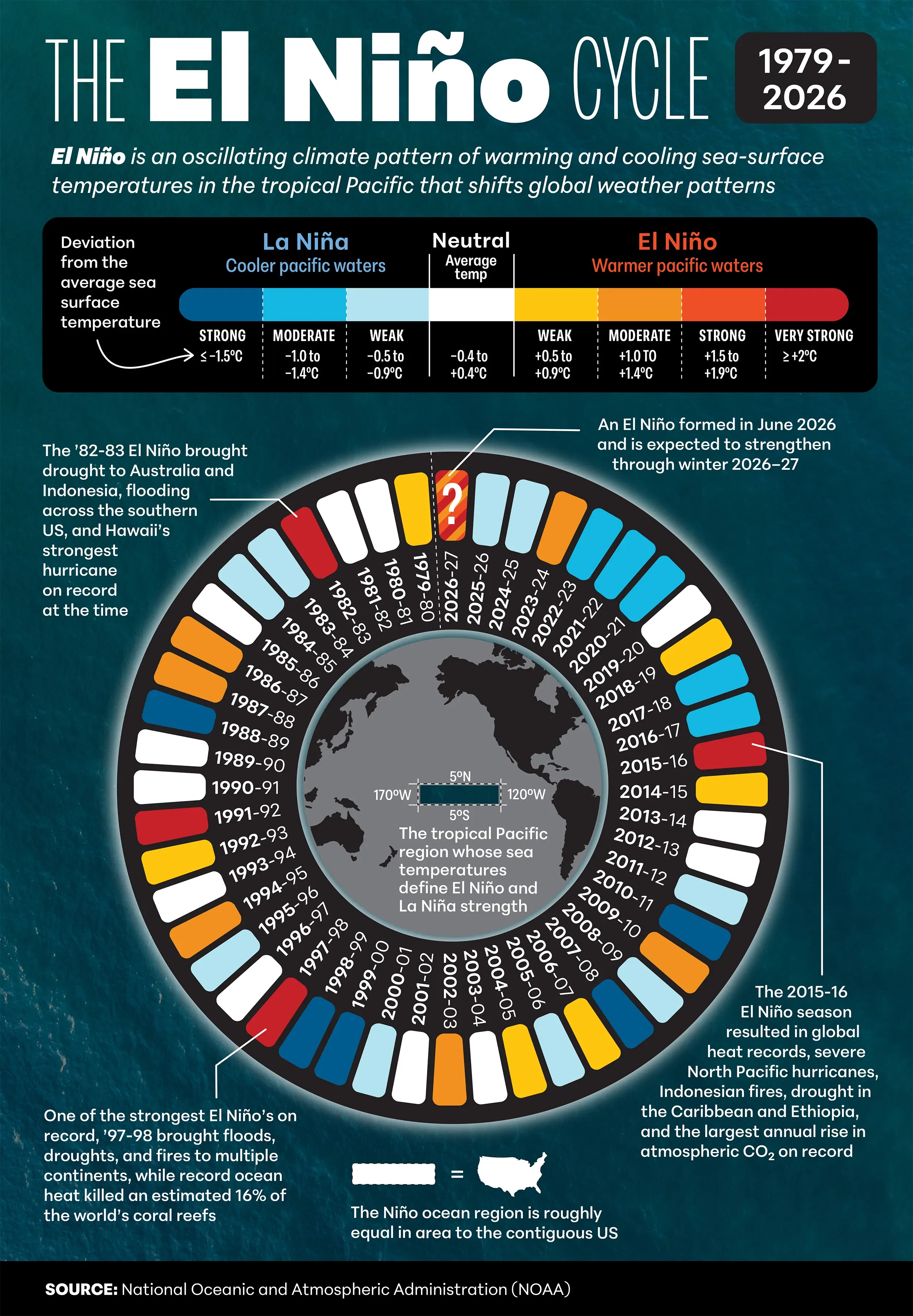
The El Niño Cycle: 1979-2026
El Niño: A Climate Cycle That Shapes the Planet
A difference of just 1–2°C (2–4°F) in the surface temperature of the tropical Pacific Ocean can reshape weather around the world. Spread across millions of square kilometers, that seemingly small change represents an immense amount of heat that alters atmospheric circulation, shifts the jet stream, and influences rainfall, drought, hurricanes, and storms on nearly every continent.
What Is El Niño?
El Niño is one phase of the El Niño–Southern Oscillation (ENSO), a recurring climate pattern in the tropical Pacific Ocean that affects weather worldwide. ENSO alternates irregularly between three phases:
- El Niño – warmer-than-average Pacific waters
- La Niña – cooler-than-average Pacific waters
- Neutral – near-average ocean temperatures
These phases typically occur every 2 to 7 years, although their timing and intensity vary a lot. Scientists understand how ocean temperatures, trade winds, and atmospheric pressure interact to drive ENSO, but the processes that trigger transitions between phases remains only partly understood.
Measuring ENSO
ENSO strength is measured using the Oceanic Niño Index (ONI), developed by NOAA's Climate Prediction Center. This tracks rolling averages of sea-surface temperature anomalies in the “Niño 3.4 region” of the Pacific, which lies between North America and Australia (5°N–5°S, 170°W–120°W). This section of the ocean covers roughly 5.5 million square kilometers—slightly larger than the contiguous US.
Between 1979 and 2025, the oscillation produced:
- 15 El Niño episodes
- 19 La Niña episodes
- 12 Neutral years or transitional periods
Neutral conditions are an important part of the cycle, as the Pacific Ocean is frequently in neither an El Niño nor a La Niña state.
The 2026–27 El Niño Outlook
NOAA reports that El Niño conditions are now present and are expected to strengthen through the Northern Hemisphere winter of 2026–27. Forecast models indicate a high likelihood that El Niño will persist into early 2027, increasing the risk of weather extremes worldwide.
Typical El Niño impacts include flooding across parts of North and South America, drought in Australia, Indonesia, and southern Africa, disruptions to agriculture and fisheries, and increased stress on food and water supplies. El Niño years also tend to rank among the warmest on record.
An Ancient Climate Pattern
Although modern ENSO observations extend back only to 1950, evidence preserved in coral reefs and lake sediments shows that El Niño and La Niña have occurred for thousands of years.
The name “El Niño”—Spanish for “The Boy “ or “The Christ Child”—was coined by Peruvian fishermen who noticed unusually warm waters arriving around Christmas. Its counterpart, “La Niña” ("The Girl"), was adopted later to describe the cool phase of the cycle.
This chart visualizes the alternating El Niño, La Niña, and Neutral phases of ENSO from 1979 through the forecast for 2027.
Notes:
No "Strong" category El Niño events occurred during 1979–2027 (the last was 1972–73). The period shown on this chart includes four "Very Strong" events: 1982–83, 1991–92, 1997–98, and 2015–16.
Event classifications are based on NOAA's Relative Oceanic Niño Index (RONI), adopted in 2026. Some historical event intensities differ from the previous Oceanic Niño Index (ONI). The 1991-92 cycle, for instance, was previously categorized as "Strong" but is now regarded as "Very Strong."